News & Events


- About the school
- News & Events
- Academics
- Research & Practice
- People
- Archive
- Design Practice
- Global Partners
- Campus Life
- Alumni & Support
Journal of Design · Technology | Assessing and Interpreting Urban Hot-Humidity Exposure Using Social Media Data to Support Climate-Resilient City Planning
Recently, a research team led by Associate Professor Ling Wang from the Department of Landscape Architecture, School of Design, Shanghai Jiao Tong University / Center for Sustainable Ecological Research published an academic paper titled "Mitigating and Adapting to Extreme Climate: Developing a Novel Assessment Model for Unexplained Hot-Humid Exposure in Metropolitan Areas" in Sustainable Cities and Society (Impact Factor: 12.0; JCR Q1; SCI Q1, Chinese Academy of Sciences; Top Journal), an internationally renowned journal on urban sustainability.
Background:
Under the combined effects of global climate change and rapid urbanization, hot-humid exposure (HHE) has become a critical issue threatening public health and urban sustainability. Traditional assessment models rely on static population data, neglecting the cumulative effects of residents' dynamic mobility behaviors on exposure risks, which leads to risk underestimation and insufficient explanation of causation mechanisms.
Regarding HHE mitigation, previous cases reflect two distinct governance philosophies: one emphasizes technological environmental solutions, while the other focuses on social behavioral adaptation. This dichotomy is also evident in academic debates. The core question is: For extreme heat events, should cities prioritize modifying the built environment or reshaping human behaviors?
The "environmental modification school" advocates reducing heat radiation by optimizing building material albedo and increasing water bodies and green spaces. In contrast, the "behavioral regulation school" argues that high-density cities should pay more attention to optimizing activity patterns (e.g., staggered access hours) to mitigate the impacts of HHE on humans.
Therefore, the urgent task is to identify the main drivers of HHE in different urban areas, so as to develop tailored mitigation and adaptation strategies that align with both built environment characteristics and human activity patterns, thereby enhancing urban sustainability. Metropolitan Areas like Shanghai, characterized by high population mobility and complex urban structures, are in dire need of more precise assessment tools and differentiated intervention strategies.
This study innovatively proposes the "Probability-Intensity-Visitation frequency (PIV) HHE Assessment Model." By integrating social media-derived mobility data with multi-source environmental data, it breaks through three major bottlenecks of traditional assessment methods: (1) dynamic exposure quantification, (2) driver mechanism analysis, and (3) assessment accuracy. The model provides an innovative solution for high-density cities to cope with extreme hot-humid climates.
Innovations:
From Static Assessment to Dynamic Behavior-Environment Coupling in Hot-Humid Exposure
1. Theoretical Model Innovation – Reconstructing the HHE Assessment Paradigm
• Breaking Traditional Framework Limitations:
Overcomes the constraints of the static "heat stress–social vulnerability–exposure" model by coupling residents' spatiotemporal behavioral dynamics (POI visitation frequency) with environmental cumulative effects (hot-humid probability × intensity).
Establishes the PIV (Probability-Intensity-Visitation frequency) assessment system, significantly improving exposure assessment accuracy.
• Data Methodology Breakthrough:
Innovatively employs social media POI visitation data (25 billion Dianping reviews, 2018–2024) to replace traditional census data.
Achieves "visitation purpose interpretability" (classified as lifestyle & commercial/public services/leisure & entertainment), resolving the limitation of mobile signaling data having "trajectories without intent."
2. Mechanism Analysis Innovation – Revealing Nonlinear Behavior-Environment Interactions
• Discovery of "Dual-Dominant Pathways":
Through random forest and Bootstrap mediation analysis, quantifies for the first time that commercial visits contribute >40% to HHE (Fig. 5).
Proves human behavior dominates in urban centers, while environmental factors dominate in suburbs, overturning the "environmental determinism" paradigm.
• Identification of Critical Threshold Effects:
Using restricted cubic spline (RCS), finds:
Green space ratio (G-PLAND) <11.75% exacerbates exposure (common in urban centers).
Water body ratio (B-PLAND) >2.99% leads to humidity effects offsetting cooling benefits (Fig. 8).
Reveals POI quality improvement follows diminishing marginal returns, providing quantitative evidence for facility optimization.
3. Planning Application Innovation – Proposing a "Risk-Behavior-Facility" Tiered Intervention System
• Risk Stratification & Management:
Classifies Shanghai’s 214 subdistricts into 8 risk zones (HHH, HLL, etc.).
Proposes dual interventions (behavioral guidance + environmental modification) for "double-high zones" (13.99% of subdistricts), e.g., dynamic pricing strategies in the Bund commercial area.
• Facility Supply-Demand Matching Algorithm:
Using mismatch index analysis, finds cooling facility gaps are larger in suburbs than urban centers, highlighting the "risk-resilience coexistence" phenomenon in city cores.
85.07% of residents prefer artificial cooling facilities, suggesting megacity HHE adaptation should extend beyond natural solutions.
Highlights:
· A cumulative, attributable model for assessing hot-humid exposure has been proposed.
· Contributions of environments and visitation to exposure were compared.
· Identified impact mechanisms of visiting points and landscape indices on exposure.
· Quantified the supply-demand matching level of resident-preferred facilities.
Abstract:
Rapid urbanization and climate change have intensified hot-humid exposure (HHE), threatening public health and environmental sustainability in Shanghai. Visitation refers to the arrival of urban residents in a specific area. Traditional exposure assessments using static data underestimate risks by ignoring repeated visitation pattern. This study leverages POI visitation data from social media to propose a novel Probability-Intensity-Visitation (PIV) model, integrating cumulative impacts of climates with visitation to assess exposure and develop mitigation and adaptation strategies, addressing three critical limitations: cumulative impacts, subjective biases and interpretability. Using Random Forest, Restricted Cubic Spline (RCS) curves, and Bootstrap resampling, this study explores the contribution, pathways and relationships between impact factors and HHE. Results reveal that two extreme high-risk zones in the urban center and medium-risk zones expanding in suburban areas. Visitation contributes over 40% to HHE exceeding environmental conditions with lifestyle and commercial visitation being the most significant drivers. Landscape pattern indices also influence exposure levels through both environmental and visitation pathways, showing nonlinear effects and threshold responses. Surveys indicate 85.07% preference for artificial cooling facilities, highlighting a supply-demand mismatch, particularly in suburban, rural, and newly developed areas. The study utilizes data from a widely used social media (Dianping) to support HHE assessment, proposes strategies for mitigating HHE through optimized visiting points and landscape planning (e.g., dynamic pricing during peak heat hours, along with considerations for green space density and edge configuration), as well as adapting to HHE by supplementing facilities, offering actionable guidance for sustainable development in the Northern Subtropical Monsoon Climate.
Keywords:
Climate change; Hot-humid exposure; Human visitation; Visiting points pattern indices; Landscape pattern indices; Supply-demand matching
Figures:

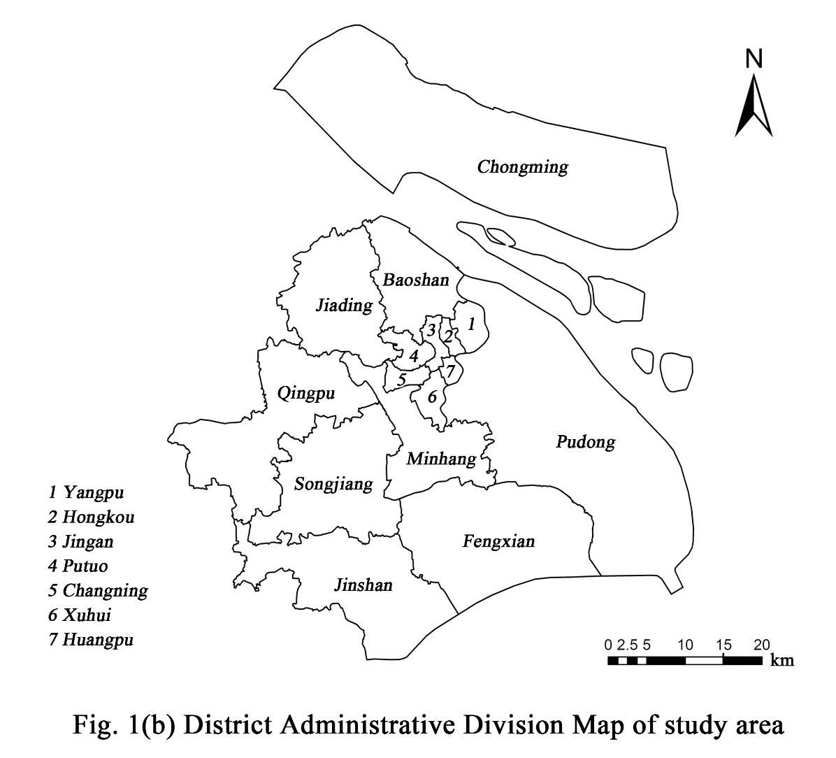
Fig. 1. Study area

Fig. 2. Research Framework
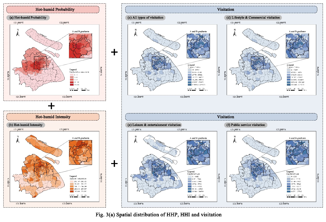
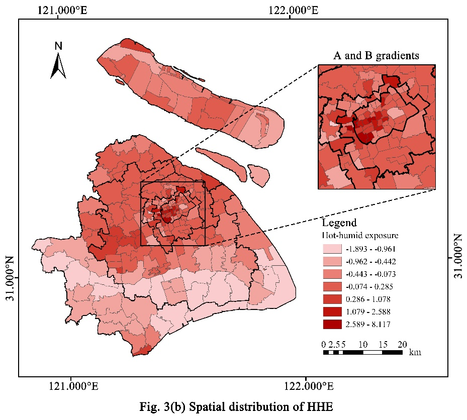
Fig. 3. Spatial distribution of HHP, HHI, visitation and HHE
(Fig. 3(a) illustrates the spatial distribution of three indicators of PIV model; Fig. 3(b) illustrates the spatial distribution of HHE)
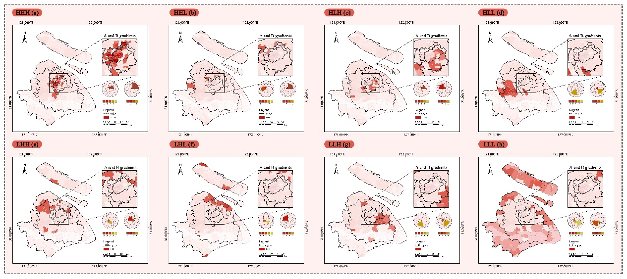
Fig. 4. Spatial distribution of HHE risk classification across Shanghai subdistricts
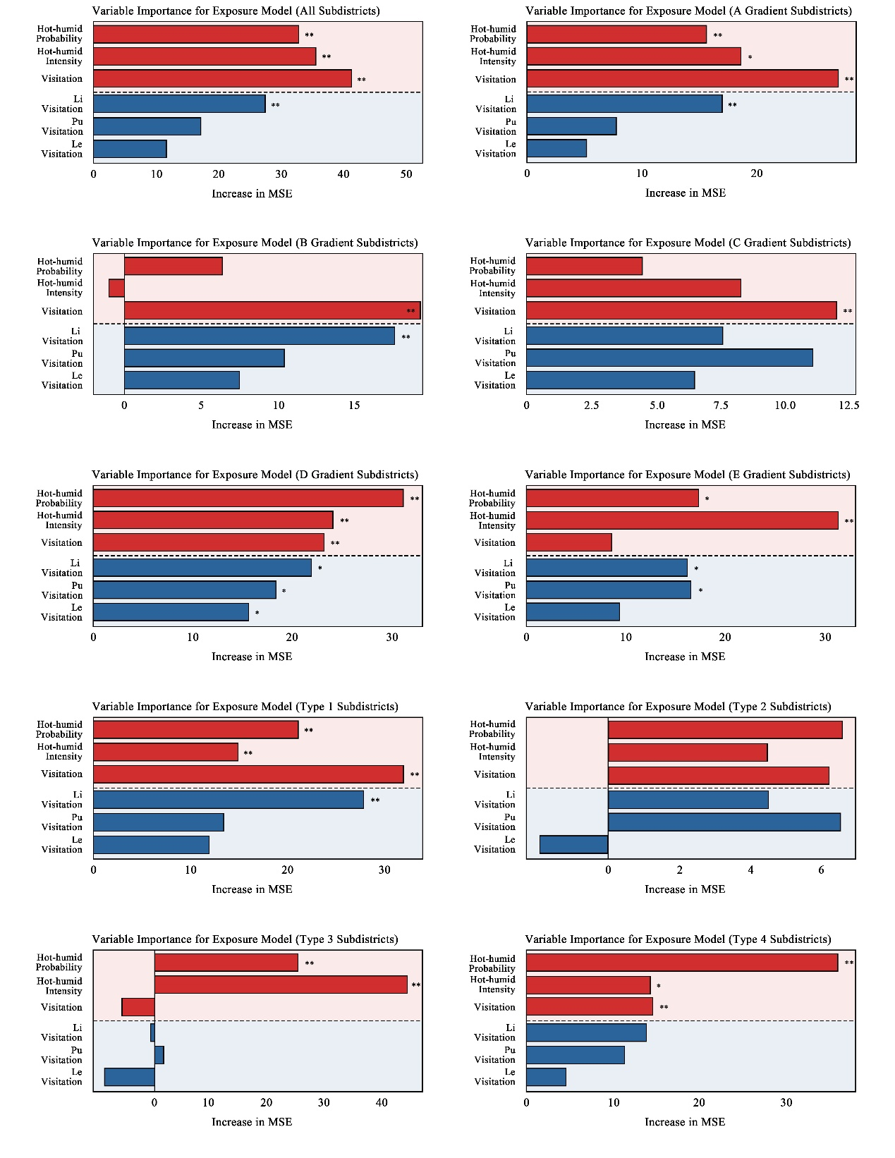
Fig. 5. Relative contribution of three indicators of PIV model and three visitation categories to HHE
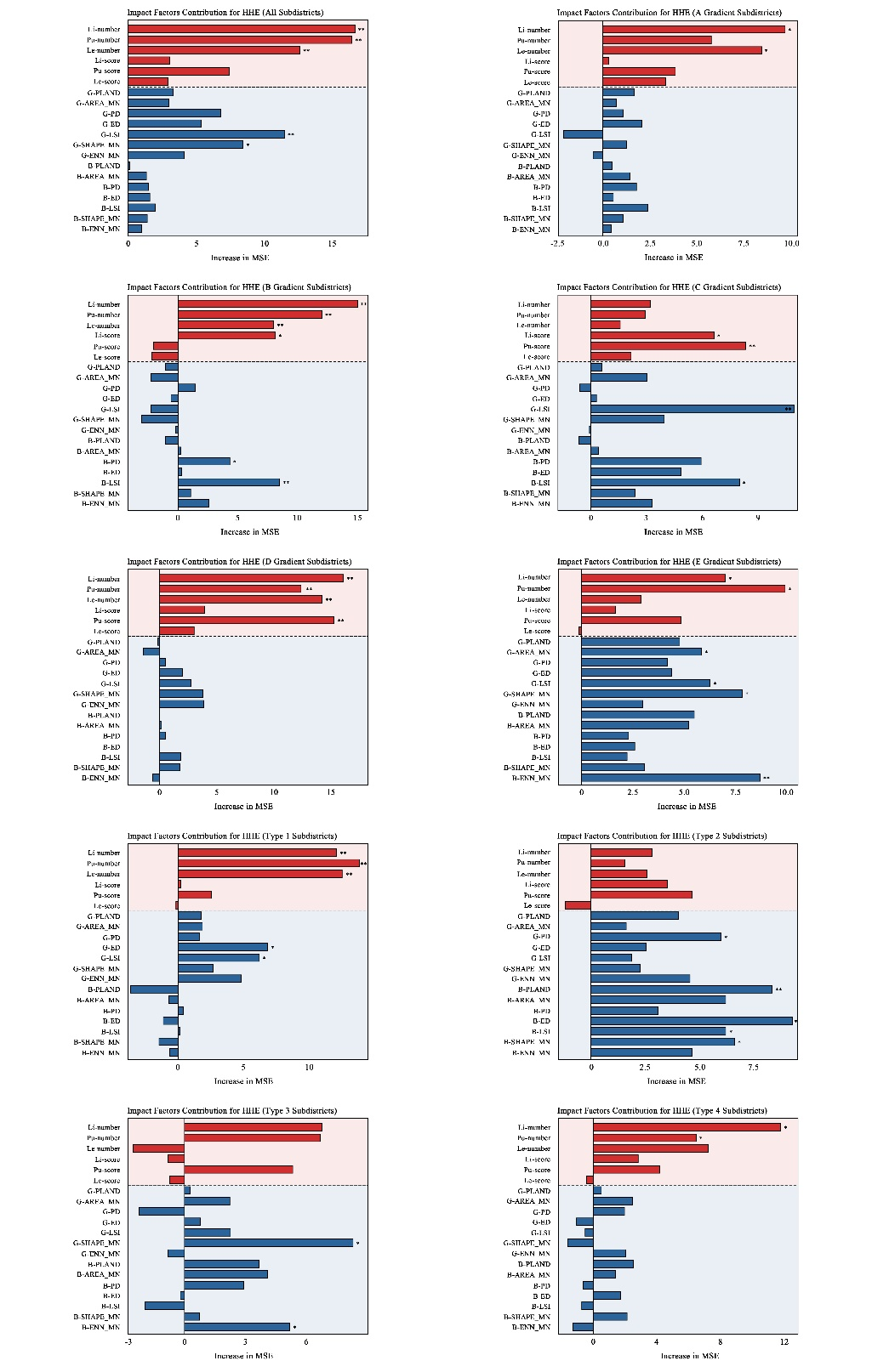
Fig. 6. Relative contribution of potential impact factors to HHE
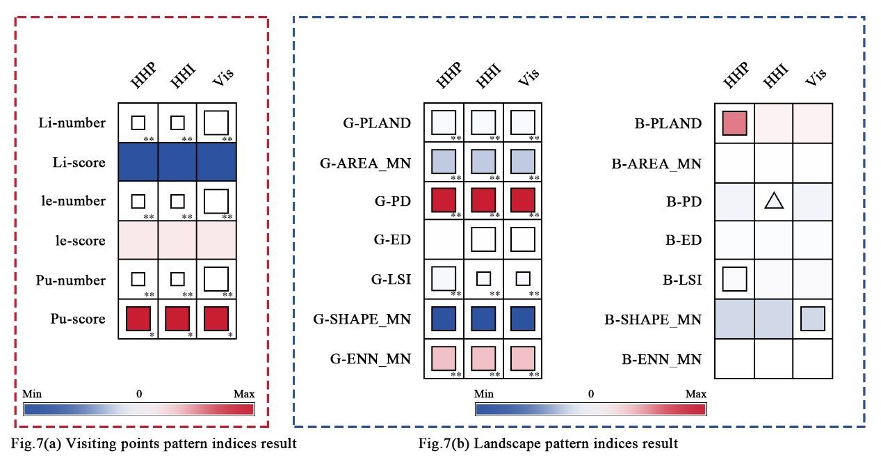
Fig.7. Mediation effect test results of potential impact factors on HHE
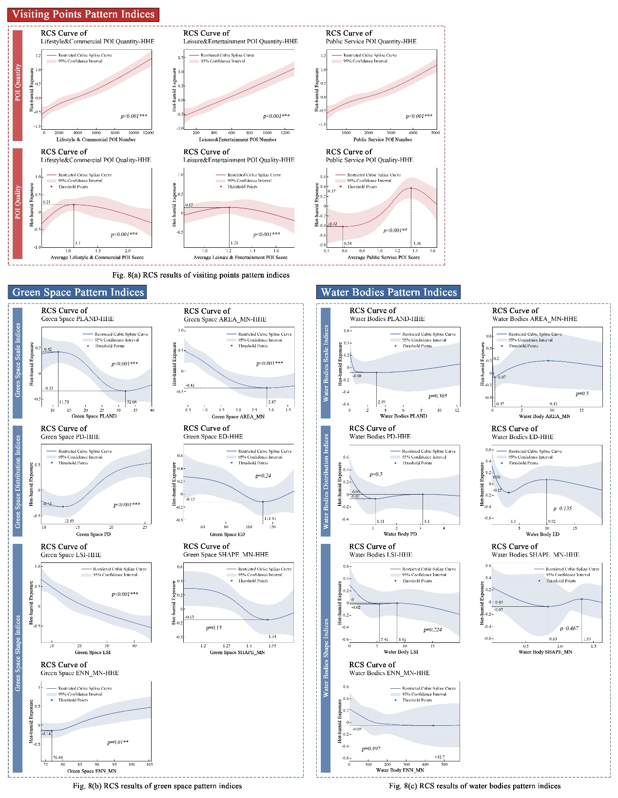
Fig. 8. Results of the RCS analysis for potential impact factors and HHE
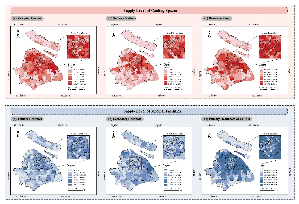
Fig. 9. Spatial distribution of HHE adaptive facilities supply level
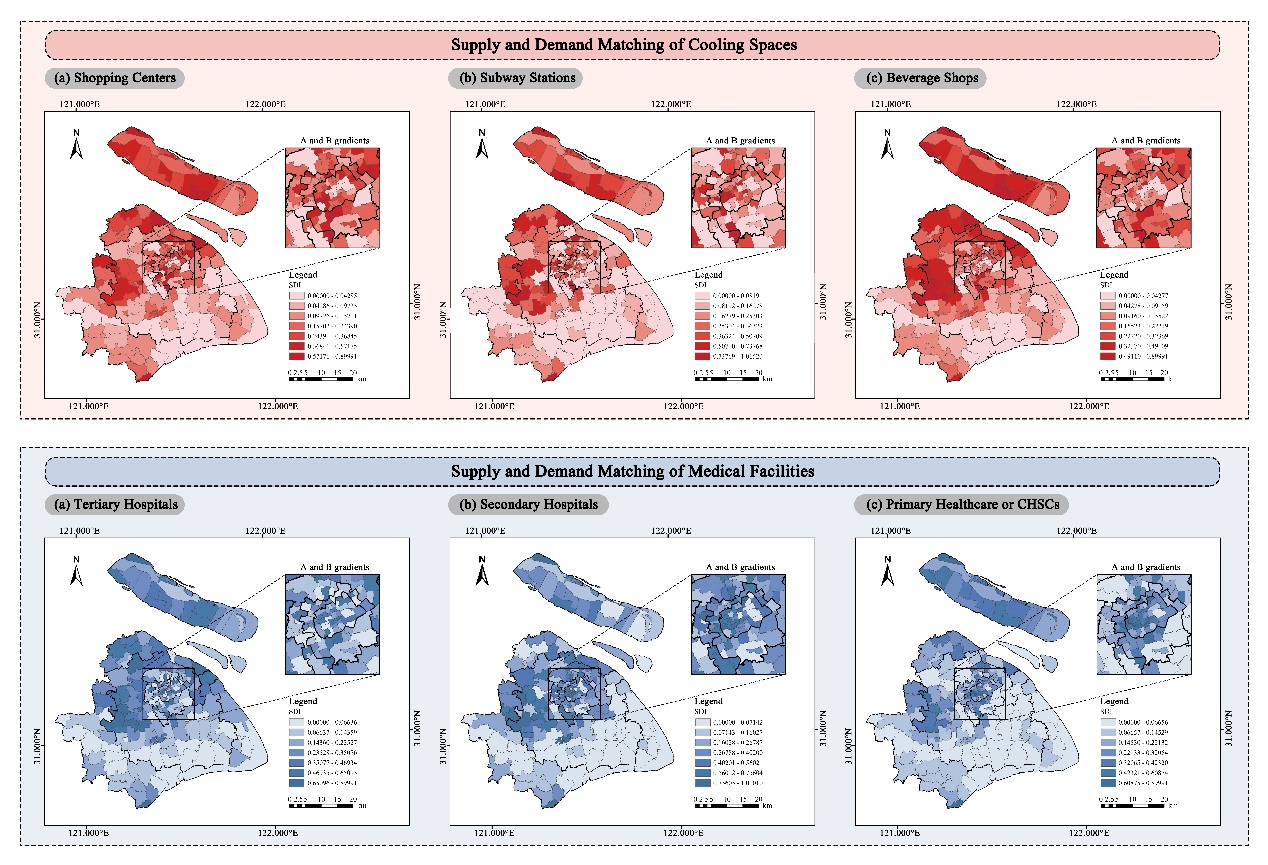
Fig. 10. Spatial distribution of HHE adaptive facilities supply-demand matching level
Citation Format:
Guo, Y., Shen, X., Qin, Y., Che, S., Wei, M., & Wang, L. (2025). Mitigating and adapting to extreme climate: Developing a novel assessment model for unexplained hot-humid exposure in metropolitan areas. Sustainable Cities and Society, 127, 106432. https://doi.org/10.1016/j.scs.2025.106432
The first author of this paper is Yuqian Guo, a student in the International Master of Landscape Architecture (MLA) program at Shanghai Jiao Tong University's School of Design, with corresponding author being Associate Professor Ling Wang from the same university's Department of Landscape Architecture. The research team also included Assistant Professor Xiwei Shen from the University of Nevada, Las Vegas' Department of Landscape Architecture, Postdoctoral Researcher Yifeng Qin and Professor Shengquan Che from Shanghai Jiao Tong University's Center for Sustainable Ecological Research, along with MLA student Minghao Wei. This study received joint funding support from the Shanghai Housing and Urban-Rural Development Management Committee's Annual Research Project (No. 2024-001-004) and the Shanghai Science and Technology Innovation Action Plan's Belt and Road International Cooperation Project (No. 22230750500).