News & Events


- About the school
- News & Events
- Academics
- Research & Practice
- People
- Archive
- Design Practice
- Global Partners
- Campus Life
- Alumni & Support
Landscape Engineering and Digital Landscape
2024 MLA Fall Semester

Course Introduction
The "Landscape Engineering and Digital Landscape" elective course (taught in English) offered by the Department of Landscape Architecture at Shanghai Jiao Tong University's School of Design follows the requirements of the National Steering Committee for Professional Degree Education in Landscape Architecture. Targeting first-year master's students, this 48-hour integrated theoretical and practical course cultivates versatile talents with both academic innovation and technical implementation abilities. The course centers on dual modules of "Advanced Engineering" and "Digital Landscape," with the latter focusing on parametric algorithmic thinking (such as Grasshopper, AIGC), driving students from data modeling to dynamic solution generation to address complex issues like ecological restoration and infrastructure updates.
The Fall 2023 semester yielded fruitful student outcomes, with one group's work winning the CHSLA 2024 Design Excellence Award (Graduate Category) in the Chinese Society of Landscape Architecture (CHSLA) Student Design Competition, demonstrating the course's deep integration of academic rigor and practical feasibility.
This semester (Fall 2024) has strengthened topic requirements, with design topics combining self-selected sites and teacher recommendations to ensure equal emphasis on academic depth and practical value. Students should prioritize sites suitable for field research (such as urban public spaces, ecologically sensitive areas, campus green spaces) based on their interests and professional background, or choose teacher-recommended projects with research potential (such as coastal flood control, industrial heritage restoration). Topics are divided into two categories: Research Projects (Groups 1 and 2) emphasize theoretical exploration and preliminary research, requiring literature review and parametric simulation to propose innovative design strategies for ecological restoration and hydrological optimization; Implementation Projects (Groups 3 and 4) emphasize site intervention and technical implementation, requiring algorithm-driven design based on real data (such as pedestrian flow heat maps, environmental parameters) to solve practical problems like infrastructure updates and functional activation.
All topics must demonstrate the application of digital landscape technology (such as Grasshopper, AIGC), ensuring design logic has data support and operability. Cross-disciplinary methods are encouraged, integrating engineering technology and ecological thinking. Final outcomes must balance academic rigor (such as analytical models, theoretical frameworks) with practical feasibility (such as construction simulation, dynamic solutions) to provide innovative and effective solutions for the landscape architecture field.
Teaching Team

ZHU Liqing
Ph.D., Associate Professor at Shanghai Jiao Tong University.

FU Kai
FLO景观设计事务所创始合伙人
Founding Partner of FLO Landscape Design Studio.

Simon Yue [Canada]
Former Director of International Design Center at East China Architectural Design & Research Institute (ECADI).
Student Works
Group 1
HOU Xiaoyu XU Ruixin WANG Xinran
Project Description
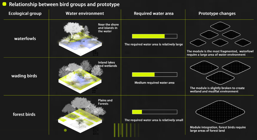
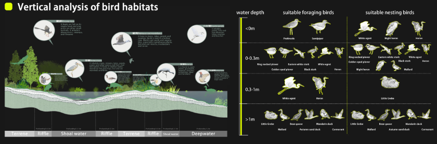
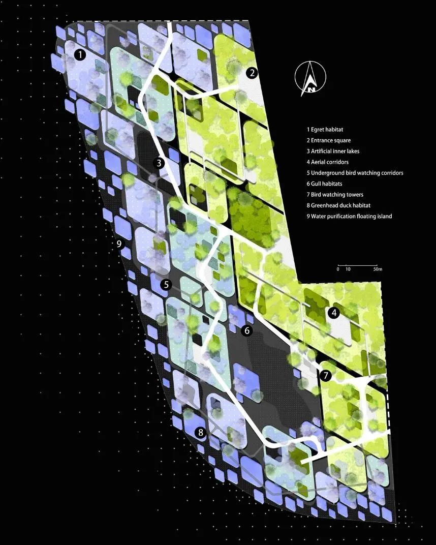
With the acceleration of urbanization, the habitat of birds is shrinking. Designing a park that can provide habitat for birds has become a necessary measure of urban ecological design. The aim of the project is to create a safe and comfortable habitat for birds through a detailed study of their habitat needs, while also providing an environment for urban residents to live in harmony with nature. In the design, the first step is to provide the basis for the layout of the park through the study of the habitat. The flight distance of birds determines their range of activities in the habitat. Therefore, reasonable planning of the habitat space of birds to avoid direct interference between human activity areas and bird habitats can effectively reduce bird fright and protect the living space of birds. The core of the layout is based on the diamond shape, which not only has aesthetic significance, but also plays a good role in organizing water flow, optimizing terrain, preventing bank erosion, etc., and flexibly adjusts the size and vertical height of the diamond shaped unit according to the habitat needs of different birds. Wetland birds require relatively flat areas, while forest-dwelling birds prefer higher vegetation and sheltered Spaces. There are no strict boundaries between each unit, and all landscapes are like flowing blood, nourishing each other and working together to build a harmonious and resilient ecosystem.
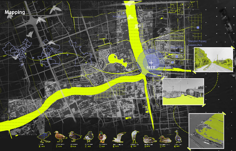
▲ 前期分析图

▲ 剖面图
▲ 总平面图
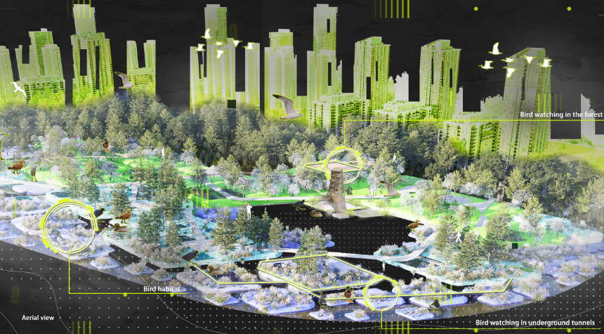
▲ 鸟瞰图

▲ 模型图
Group 2
YAN Mengling WANG Yueyan LI Hongying HE Chenjing
Project Description
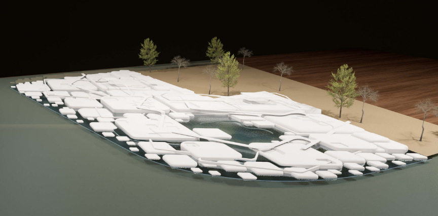
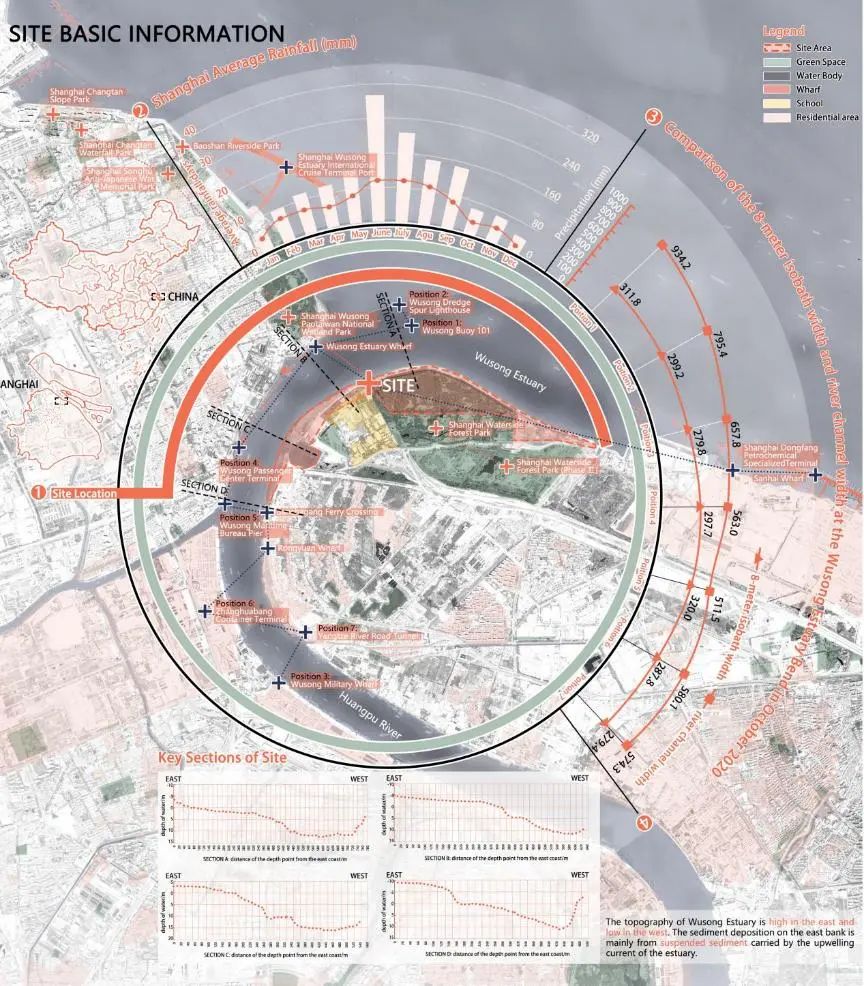
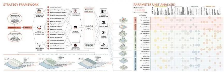
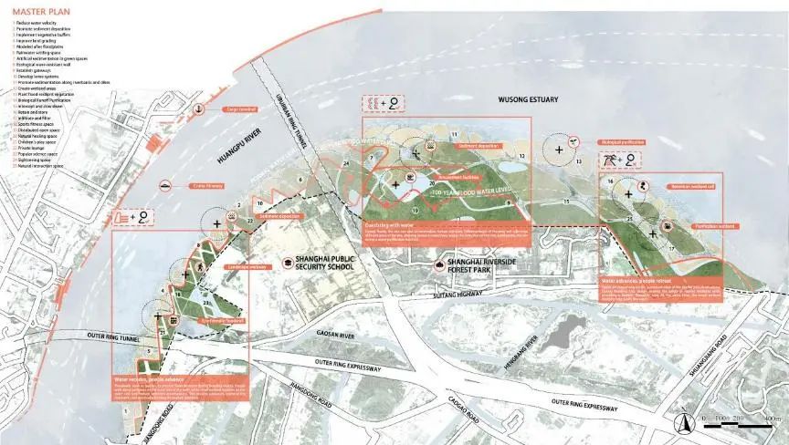
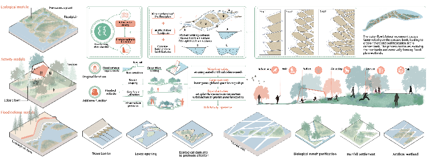
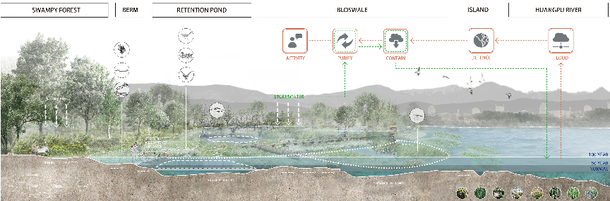
The design simulates the formation of an oxbow lake in river hydrodynamics, primarily addressing flood control, pollution treatment, human activities, and sediment deposition, aiming to mitigate the impact of rising sea levels and flood intrusion on the Wusong Estuary. The entire design plot is divided into three major spaces: " water recedes, people advance," "coexisting with water," and "water advances, people retreat." By integrating various functions, these three spaces are further subdivided into different modules to more comprehensively and specifically address the main issues on site, providing a dynamic and sustainable solution. In addition, the site includes a variety of public spaces designed for human activities, allowing citizens to closely experience hydrological changes. The landscape combines natural processes with artificial interventions, not only solving specific site issues but also offering landscape measures to defend against flood invasions in coastal cities.

▲ 轴测图
▲ 模型图
Group 3
LIN Sixu SHAN Wenjie HONG Yang YANG Yuxuan XUN Hongtao
Project Description
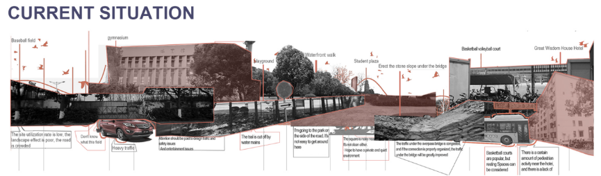
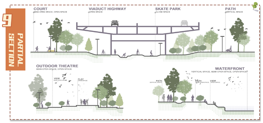
The site is located within the green spaces of Shanghai Jiao Tong University's Minhang Campus, Shanghai. A viaduct spans the site, leaving only two underground passages connecting the east and west campuses. This creates significant issues, including air pollution, noise interference, and wasted space, which are pressing concerns shared by the university administration, faculty, and students.
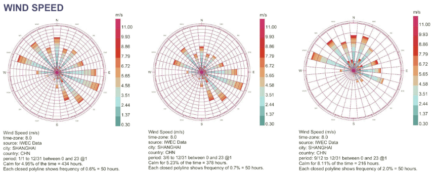
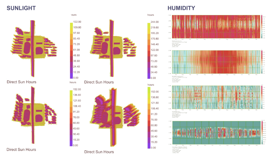
Addressing three primary challenges—lack of connectivity, insufficient functionality, and inadequate infrastructure—we employed data-driven and parametric design approaches to propose solutions.
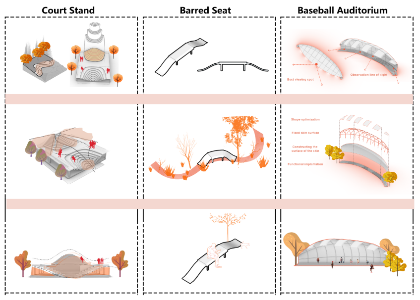
Firstly, we utilized pedestrian flow data and the wool-string algorithm to establish optimal pathways connecting key origins, such as dormitories, teaching buildings, and roads, with destinations like the student activity square, sports fields, baseball stadium, and gymnasium. Secondly, based on usage intensity heatmaps, we applied a magnetic field algorithm to define more recognizable and accessible boundaries for functional zones catering to different levels of physical activity. For example, Level 1 zones include the student activity square, reading corners, and relaxation areas; Level 2 zones consist of jogging paths and cycling tracks; and Level 3 zones cover skate parks, ball courts, and athletic fields.
Guided by data-driven insights and parametric design methods, our goal is to create a vibrant campus green space with a rational layout and innovative design. This project aims to foster communication between the east and west campuses, revitalize underutilized spaces, and upgrade the site's infrastructure.

▲ 前期分析图

▲ 效果图
▲ 模型图
Group 4
CHEN Minghui CHA Xin HUANG Yan Amina
Project Description
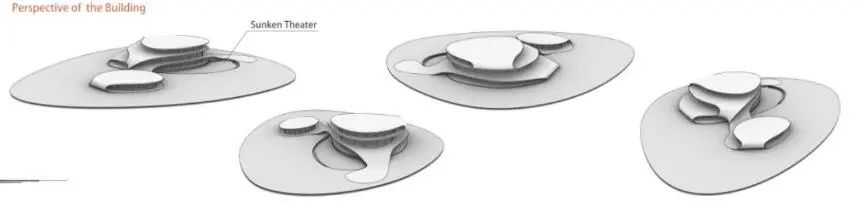
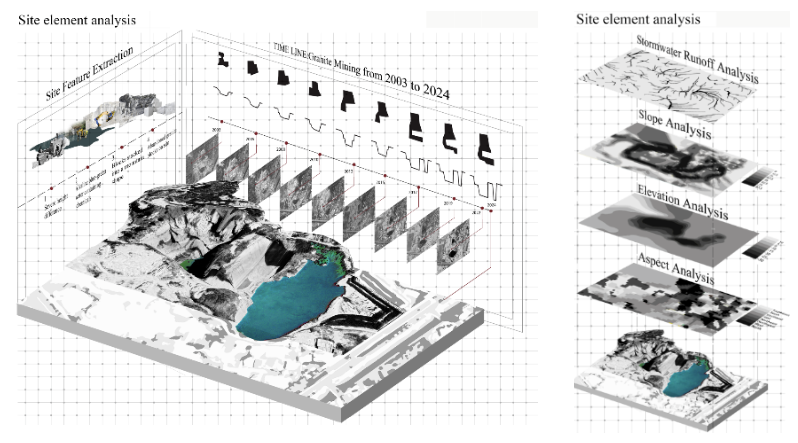
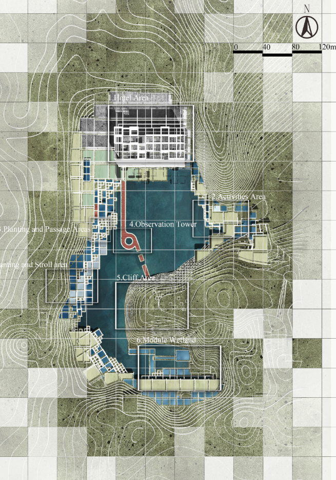
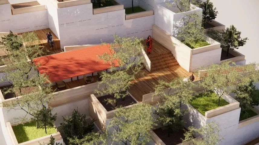
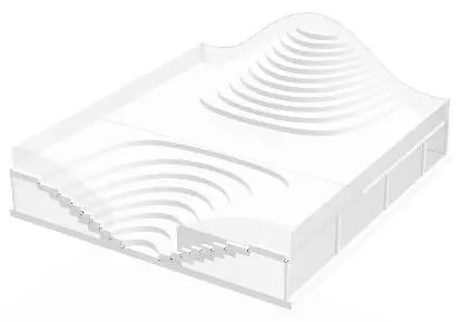
The site is a granite quarry located in Zhangzhou City, Fujian province. During the mining process, the ecology of the site was damaged, and the artificial mining also left unique site features -- regular cliff sections, square granite materials, geometric platform texture, etc., which are now planned to become the landscape of the mine hotel. We believe that human development should not cause damage to nature, but should closely integrate human needs and ecology to form an organic whole. The box represents the development of people, people's interests, but also represents the intensive and efficient mining history. This design adopts this element with strong site characteristics, uses the modular design method to carry out a series of ecological design, restores the plant ecology of the steep slope, and uses the pond to form a wetland, forming a unique pit hotel, rest space, entertainment space, etc., which not only meets the needs of people, but also creates an ecological landscape.


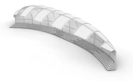
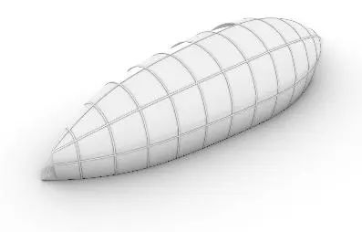
▲ 剖面图
▲ 效果图
▲ 模型图
Teachers' comments
Group 01
The first group of students, based on the problem of the continuous reduction of bird habitats in the Huangpu River basin, proposed a new model of establishing a biodiversity park for coexistence of humans and birds by utilizing the existing riverside green spaces. They conducted relatively detailed and distinctive research on bird flushing zones and human-bird coexistence. By using parameters such as the flushing distances of different birds, the water depth where birds perch, and their interactiveness with humans, they rationally set up bird habitat areas of different sizes and landscape features. They deduced a parametric prototype with a diamond as the theme by using the principle of hydrodynamics, and achieved modularization as well as its layout on the master plan. However, there is still much room for deepening the deduction and evolution of the modules. On this basis, the team introduced three kinds of bird - watching routes: treetop, water surface and underwater, making the overall design more complete and comprehensive. In the design of the bird - watching tower, the application of the diamond theme was also continued. It would be better to integrate the structure with the landscape environment. The overall design has a high degree of completion, and the graphical representation is relatively complete. New technologies such as AI generation and parametric software were used to complete the design.
Group 02
The second group of students started from a more macro perspective, hoping to combine the basic principles of hydraulics to design a complete landscape ecological protection system for flood prevention banks to deal with climate change. The site was selected at the quite distinctive Yangtze River estuary, which has relatively large tidal changes and covers a variety of land types. In the design, the students made good use of parametric methods to construct flood prevention module prototypes that are adaptable to different land types, and rationally controlled the layout of the modules on the master plan by combining parameters such as water slope and functional site size. Among all the students, the deduction and deformation of modules in the overall design of this group are the most abundant, and they also tried to design building units that are integrated with the landscape. The graphical representation is relatively clear, and the design has a high degree of completion.
Group03
The third group of students started from the perspective of optimizing traffic routes, trying to reintegrate and unify the originally separated two plots of land and several functional blocks with a complete traffic grid. The design applied the wool algorithm and the principle of magnetic lines to obtain the best human behavior routes. The overall concept is quite novel, and the data collection and module deduction are also relatively in - depth. However, the finally generated grid hopes to further highlight the sense of tension and form a clear grid positioning on the master plan. Overall, the students of this group have made a very valuable attempt. It is hoped that in the future, there will be an opportunity to further refine the master plan and express the overall design completely.
Group 04
The fourth group of students started from the two dimensions of ecological restoration and vacation tourism, and proposed an interesting solution for the reuse of the mine pit polluted by stone mining. Based on the huge height difference of the site, they reasonably utilized the parametric design scheme, combined with the steep rock texture on site, and designed the pedestrian and vehicle routes as well as the rainwater convergence routes. They arranged different modules such as ecological restoration, leisure vacation and soil retaining slope protection on the corresponding routes, which provided the possibility for the sustainable operation of the subsequent mine pit management. The overall design concept is relatively complete, and the deduction and distribution of the modules are relatively reasonable. However, the final visual presentation could be clearer and more explicit, especially the expression combined with the actual usage scenarios could be more vivid and accurate.
Student Testimonials
The "Landscape Engineering and Digital Landscape" course has been incredibly rewarding. During the learning process, I deeply experienced the infinite possibilities that digital technology brings to landscape architecture design. Through technologies like GRASSHOPPER computation and 3D modeling, we can present design works from entirely new perspectives, breaking the limitations of time and space, making designs more vivid and intuitive. This course not only broadened my design horizons but also led me to develop different design thinking. It made me understand the importance of leveraging digital technology's power in design to explore more creativity and inspiration. Meanwhile, it also helped me realize that regardless of technological advancement, care for nature and humanity remains the core of landscape architecture design, making me look forward to future challenges with anticipation.
— Yan Mengling
Though the course lasted only about half a semester, surprisingly, in such a short time, through systematic learning, we developed a preliminary understanding of parametric design. The parametric design logic training introduced us to new design methods, detailed software tutorials for beginners gave us operational foundations in parametric design software, and expert lectures on industry exploration of new technologies broadened our horizons. All these have brought more possibilities for our future theoretical and practical learning.
— Huang Yan
I not only improved my modeling skills but also deeply learned the application of Grasshopper, which led to significant progress in digital landscape design. Through the course, I mastered how to empower landscape design using AIGC technology, which opened new perspectives for my design thinking. The teachers' multi-disciplinary perspectives and creative suggestions enabled me to consider issues more comprehensively when completing coursework. This course not only enhanced my technical capabilities but also provided opportunities to interact face-to-face with experienced practitioners, giving me a deeper understanding and expectation of future developments in landscape architecture engineering.
— Lin Sixu
In the digital landscape course, I gained a deep understanding of how to analyze and simulate landscapes through parametric design tools. Digital landscape design thinking differs greatly from traditional design - traditional planning design is based on accumulated experience, while digital landscape directly addresses objective environmental change patterns, which broke my understanding of design. Through this course, I realized the enormous potential of digital technology in landscape architecture design, as it provides us with more precise tools to address various design challenges. In the future, I hope to integrate these skills into my subsequent studies and future work.
— Hou Xiaoyu
This semester's digital landscape course has been highly rewarding. I gained deep insights into cutting-edge digital landscape technologies, such as projection technology, interactive technology, monitoring technology, and more, as if opening a door to a new world of landscape design. When learning digital modeling and parametric design, I initially found Grasshopper technology somewhat obscure and difficult to understand, but as the course progressed, I gradually mastered its principles and methods. What excited me most was putting parametric design into practice, designing campus green spaces with a multi-objective optimization approach. From conception to implementation, every step was challenging but also gave me a great sense of achievement. This course not only enhanced my professional skills but also helped me understand the unlimited possibilities of integrating technology with natural landscapes, laying a solid foundation for my future career development.
— Yang Yuxuan